
SummaryWikipedia (en/ro)UNESCO Heritage Site
According to the UNESCO site:
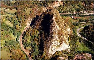
“The Băniţa fortress was constructed on a steep conical hill in the Jiu valley. The only side on which the summit was accessible was on the north, and this was defended by a strong stone wall in murus dacicus style. The fortress itself was entered through a gate leading to a monumental limestone stairway with andesite balustrades. The plateau above has three terraces at different levels.”
Location:
Province or Region: Banita village, Banita commune, Petrosani city, Hunedoara County.
Geographical coordinates:
– Latitude 47°27’ – 45°497’ North,
– Longitude 23°09’ – 29°31’ East.
Province or Region: Banita village, Banita commune, Petrosani city, Hunedoara County.
Geographical coordinates:
– Latitude 47°27’ – 45°497’ North,
– Longitude 23°09’ – 29°31’ East.
[mapsmarker layer=”6″]